Southwest by Westy, Week 1

| |


A five-thousand-mile motor tour through several states in the great American Southwest, visiting sites both historic and prehistoric: Mesa Verde, Bryce Canyon, Zion National Parks, and more.

What’s so great about the Great Plains?
Desolate. Flat. Dark, and lonely.
All these fail to truly capture the topographical and emotional essence of a long night drive across the heartland.

Seventy million years ago, when the vast North American inland sea drained away, the landscape which emerged here was the extensive, nearly flat seabed of the former ocean, with nary a hill nor a dale rising above the smooth horizon.

So today the road has nothing to climb, nothing to skirt. The interstate highway engineers must simply have chosen a compass point and begun pouring concrete. Even within the narrow corridor of highway reflectors reaching into the black distance, I think I can see the curvature of the earth …

Day 1: 2:00 a.m., Somewhere in Central Nebraska

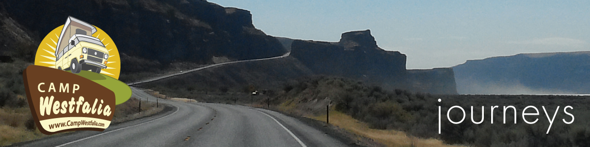
If you’ve seen one mile of highway in the heartland, you’ve seen them all, and I don’t want to look at every one of them. Hence the long night drive. But I derive a certain satisfaction from making good headway across these immeasurable distances, in light traffic and under the cover of darkness. Out here on the black highway, sailing along under the stars, it’s just me and the truckers. Even Lorie, my partner and faithful traveling companion, has folded the back seat down into a bunk and now sleeps to the rhythm of concrete expansion cracks passing beneath our wheels. So begins our great Southwest adventure.

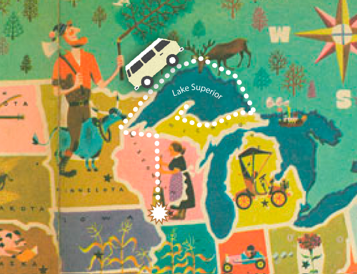
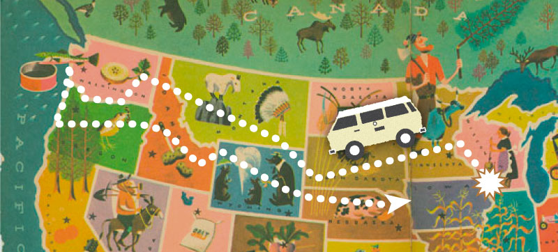
Leaving our home in southern Wisconsin about 3:00pm on a Friday afternoon, we have driven our 1983 Volkswagen Vanagon Westfalia camper south into Illinois and then swung west onto I-80, bound for Denver. Far ahead, I watch the setting sun fall behind the horizon, but I continue driving all through the night.

By 5:30am Saturday morning, my growing fatigue has developed a resistance to the repeated dosages of convenience store coffee. Even the AM talk-radio crackpots fail to keep my interest. While I’ve been driving the dark side of the planet, the sun has been traversing the light side, and now reappears in my rear-view mirror to begin a new day.

After 13 solid hours on the road, it is time to rest. I swing into a truck stop, scuttle in between the Peterbilts, turn off the engine, and join Lorie for a few hours of peaceful slumber …

Day 2: Elm Creek, Nebraska

westfalia-truckstop

At 8:30am we are awakened by the call of the open road, and by the sound of traffic already on it. After taking on fuel, food, and coffee we resume our journey. By mid-afternoon we arrive in the mile-high city of Denver. Being the gateway to the Southwest for those of us who live in the upper Midwest, we stay here only long enough to enjoy a walk on the 16th Street pedestrian mall, visit the lovely old Union Station, and share a chicken wrap at a sidewalk bench.

We head south out of Denver, fighting evening rush-hour traffic on I-25, and finally arrive in Castle Rock, CO, about 7:00pm. Twenty-nine hours and 1033 miles after leaving home, we find a place to pull off for the night, pop the top on the camper van, and settle in for a luxurious full eight hours of sleep.

Day 3: Castle Rock, Colorado

We make little progress today. I suppose for every adventure there is an equal and opposite misadventure, and our first comes today, just west of Walsenburg, CO. Upon beginning our ascent over the first range of the Rockies, the engine temperature gauge rises dangerously and the warning light flashes. Pulling over to let it simmer down and replace some lost coolant, we resume our climb only to have the same thing repeated. It seems our 20-year-old coolant-system cap can no longer hold back the pressure against the thin mountain air, and begins leaking anti-freeze.

We reluctantly but wisely retreat back down the hill and by the time we pull into a Pueblo auto parts store and install the four-dollar replacement, it is late afternoon. We decide to camp at a nearby state park.

Day 4: Pueblo, Colorado

Great Sand Dunes National Monument

Over fresh-made huevos rancheros and breakfast burritos in a Mexican diner in Pueblo the next morning, we write postcards to friends and pore over our maps. Today we will turn westward and enter those mountains which until now have only been obscure and distant peaks growing ever larger on the horizon. Retracing our route of yesterday, we continue south on I-25, and swing off at Walsenburg to take Colorado State Hwy. 160 west into the Sangre de Cristo range of the Rockies. The stone-faced, snow-capped pyramids loom ever larger before us until the highway begins a long, winding climb. The engine temperature holds steady today and we soon find ourselves at the summit of North La Veta Pass—9413’ ASL. There is little time to enjoy the view, as the pavement quickly begins its descent and we pick up speed for the cruise downward.

A unique set of climatic circumstances has created a singular place here: Great Sand Dunes National Monument. Westerly winds sweeping across this broad plain were once able to pick up and carry vast quantities of the fine sand which comprised its surface, until they came to the base of the Sangre de Cristo mountains. The wind raced upward on the western slopes but, unable to loft the sand up and over, dropped it at the foot of the mountains. Collecting here over several thousand years, the sheer volume of sand is incomprehensible, the dunes covering over 40 square miles and rising to 750’, the largest in North America. Though present conditions no longer deposit sand, the dunes are still relentlessly shaped and changed by the winds.

Great Sand Dunes National Monument2

In the beautiful, newly redesigned campground we choose a nice cozy site bounded on one side by pinyon and juniper, with a view of the nearby dunes and the mountains on the other. Tawny mule deer traipse through the campsites, grazing on the greenery. After a quick lunch in camp we drive down to the trailhead and venture out onto the vast sand sheet at the foot of the dunes. The sheer immensity of the dunes is not truly appreciated until we have walked toward them, and walked, and walked, their golden waves and ripples and crests rising higher and higher to fill the sky before us.

Later that evening around the campfire, the moon makes a brief appearance shortly after sunset, then chases the sun over the distant San Juan mountains. As the fire subsides to embers, a brilliant shooting star streaks across the darkened sky, east to west, trailing blue and green sparks that shimmer and almost audibly crackle. Perhaps it points the way to our continuing journey westward …

Day 5: Great Sand Dunes National Monument, Colorado

The Westy gives us trouble this morning, but of another kind; repeated attempts to start her fail to produce anything but clouds of smoke. Finally rolling silently out of our campsite and down the hill, we pop the clutch and the engine fires right up. Once warmed-up, the van performs flawlessly the rest of the day–and will continue to do so every day after that–except requiring a similar rolling start most mornings. This is usually little more than a persistant inconvenience, but in those morning locations without a suitable hill, an old-fashioned manual push-start is called for, which is a discouraging way to achieve one’s daily workout.

We leave Great Sand Dunes about noon, again swing west on Hwy. 160, and enjoy lunch at a picnic table beneath cottonwood trees in a grocery-store parking lot in Alamosa. In the branches overhead, raucous and hungry crows await our leftovers. We leave town and get a running start for our climb to the Continental Divide.

Wolf Creek Pass

The highway shifts upward and we begin our ascent, climbing up at steepening angles along one side of the valley leading up to the pass. Downshifting through the range—fourth gear, third, sometimes even second—we eventually settle into a low-gear, slow-speed climb, Pass Creek coursing down the steep, rocky gorge. Higher and higher we climb, every curve revealing yet more elevation to be gained, engine thrumming, ears popping. Even our can of Pringles potato chips threatens to blow its freshness seal. Patches of snow grow larger and closer together until the ground is covered by the white stuff. Finally the grade lessens, the road gradually levels and we suddenly find ourselves at the summit of Wolf Creek Pass—10,850’ASL.

Wolf Creek Pass4

This is the Continental Divide, the very backbone of North America, rugged and raw and exposed. Like the peak of a roof, all lands east of here drain to the Rio Grande, Missouri, and Mississippi Rivers, eventually emptying into the Gulf of Mexico in the Atlantic Ocean. All parts to the west flow to the Colorado, Columbia, and other western rivers which pour themselves into the Pacific. At the top of the pass there is a vehicle turnout and a plaque marking the place.

We pause here and disembark to stretch our legs, shoot snowballs at one another, and enjoy the moment. I notice that at one end of the turnout, the snowmelt trickles down the road back the way we came, while at the other end of the turnout, the meltwater runs down the pavement in the opposite direction, to the west. One single snowbank melting into two distant and separate oceans …

Wolf Creek Pass

Clambering back in the van, we roll down the 7- and 8% grades on the western side of the summit road, descending into a beautiful mountain valley laced on both slopes with pines and aspen in full autumn color, and shortly after dark arrive in Durango, CO. Having spent the last few nights sleeping in the camper van at various campgrounds and Wal*Mart parking lots, we splurge a bit and take a room in a good hotel and enjoy dinner downtown before retiring.

Day 6: Durango, Colorado

Durango & Silverton Narrow Gauge Railroad

One of the highlights of a visit to historic Durango, CO, is the Durango & Silverton Narrow Gauge Railroad. Built in 1881 to haul silver and gold ore out of the San Juan Mountains, it is estimated that over $300 million in precious metals was transported over the route. Today, the ore is gone and the mines gone bust, but there is still plenty of loose change to be found in the pockets of tourists, and a few hundred thousand passengers ride the old rails each year.

Happily, the elegant old downtown hotel we unwittingly chose last night—the General Palmer—was built and operated by the same magnate who owned the original rail line, and is located not 100 paces from the D&SNGRR depot. Beside the platform, the old steam locomotive puffs and hisses, blowing smoke, and we board the restored passenger coaches to take our seats.

Durango & Silverton Animas river

Now called the D&SNGRR, the railroad continues to provide year-round service operating a historical train with rolling stock indigenous to the line. The coal-fired and steam-operated locomotives are 1923-25 vintage and are maintained in original condition.

With a couple blasts of the whistle and a jerk of the couplers, the train pulls out of the station promptly at 8:15am and we make our way out of Durango. The rails soon converge with the Animas River and we begin to follow it northward toward Silverton. Sometimes skirting its banks, or crossing it on bridges high and low, or winding our way along narrow canyon ledges far above the roaring water, the Animas will be our near-constant companion for the 45-mile, 2800-foot ascent to the old silver mining town.

Silverton CO

We make several stops along the way; some to pickup passengers at tiny stations in the forest, some to take on water from large tanks, some for no apparent reason whatsoever. After the third unexplained stop somewhere in the middle of the woods, the conductor comes through our car to apologize; the locomotive is having a bit of trouble today and must pause periodically to build up a head of steam for the next climb. I think of the sweaty locomotive fireman who must hand-shovel nearly six tons of coal into the firebox, to boil almost 10,000 gallons of water for the round trip.

Strolling the station platform after our rail excursion, I am struck by several similarities between a 1983 diesel Westy and a 1923 Mikado steam locomotive–both: produce clouds of smoke when departing; pause to take on water before attempting to climb steep grades; generally depart on time but arrive late; elicit smiles and waves from small children and other passersby, with requests to hear the horn.
Strolling the station platform after our rail excursion, I am struck by several similarities between a 1983 diesel Westy and a 1923 Mikado steam locomotive. Both produce clouds of smoke when departing; pause to take on water before attempting to climb steep grades; generally depart on time but arrive late; elicit smiles and waves from small children and other passersby, with requests to hear the horn.

After a few more such stops we finally arrive in the historic town of Silverton, CO, nestled in a green and rocky mountain valley, and we quickly disembark for lunch. After cheeseburgers in a local diner, Lorie heads off for shopping in the restored downtown district while I seek out the original and unvarnished fringes of this rough former frontier town.

Returning to Durango in late afternoon, we do a bit of shopping in the historic downtown district, enjoy perhaps the best Mexican dinner ever at Francisco’s Restaurante Y Cantina on Main Ave., then retire to our room at the General Palmer.

Day 7: Durango, Colorado

Mesa Verde National Park

It’s only about a half-hour’s drive through high desert country from Durango to Mesa Verde National Park, so it is mid-morning when we arrive at the gate. We quickly choose a campsite and then head farther into the park for lunch at the Far View restaurant, then to the nearby visitor center for maps and information. The large namesake mesa of the park is shaped rather like an outstretched human hand when viewed from above, with palm facing downward and fingers splayed out. A park road loops out onto several of these ‘fingers’ of high, flat ground, and offers views down into the narrow canyons between them.

It is on these mesa tops that the early Anasazi settlers–now referred to as the Ancestral Puebloans– built their homes and raised their crops of corn, beans, and squash. A drive along the Mesa Top Loop Road offers ample opportunity to visit several partially excavated Puebloan dwelling sites atop the mesa. Conveniently arranged in chronological order as they developed through time, the sites represent different eras in domestic development of these ancestors to today’s Pueblo Indians. Around a.d. 750, they began settling into small villages, the Spanish word for which is “pueblo”. Construction techniques of these village houses evolved over time, using the same fundamental materials—wood poles, natural or cut stone, adobe, and even plaster—but in a changing variety of methods.

Upon returning to camp, we meet a couple of women travelling in their 1987 Vanagon Westfalia, in the midst of a 9-month roadtrip. After the requisite greetings and chatter about our vans and our trips, they ask if our van has a name. We admit that she does not, but promise to start thinking about it.

Next: Week two of this road trip, when we visit Bryce Canyon and Zion National Parks, and more!

Similar Articles

Leave a Reply

Your email address will not be published. Required fields are marked *